Walk to discover the Bièvre
Categories : City Guide, published on : 2/13/25
We offer you in this article a walking tour along the Bièvre, a small river that once flowed through the neighborhood, and which we will discuss in more detail later. Although the river no longer exists, during this walk you will be able to discover its course. We have created this itinerary based on an old map of the river, which we have tried to follow as closely as possible. It's an opportunity to discover the most beautiful spots of the 13th and 5th districts.
About the Bièvre
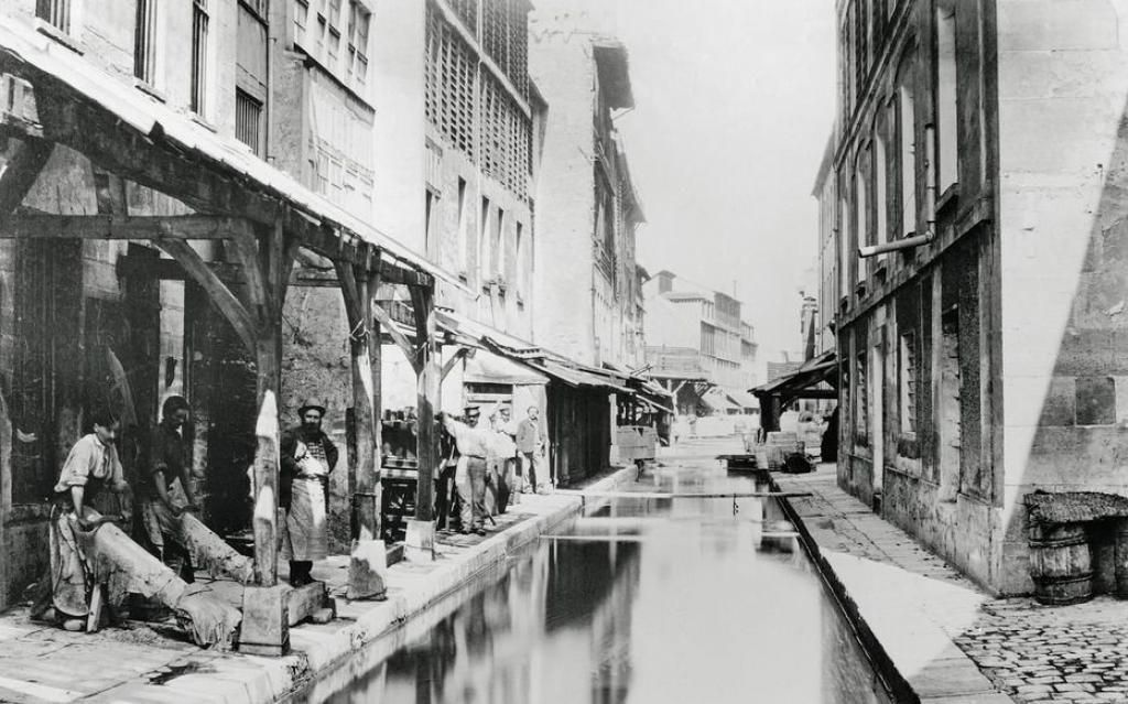
The Bièvre is a river about 40 km long that starts in Guyancourt, south of Paris (Yvelines 78) and ends in the Seine. The part of the Bièvre that runs through the 13th and 5th districts of Paris was completely covered in 1912 and now flows into the sewer system. The Bièvre gets its name from "biber", the Latin word for "beaver". Along its course, bronze medallions have been placed on footbridges by architect Benoît Jullien and the AEP Normand study, showing where the river once flowed.
Starting the Walk
The starting point of the walk is located in the heart of Kellerman Park, at the southernmost tip of the 13th district. Unfortunately, there doesn't seem to be any indication of the Bièvre in the park, but perhaps you'll have better luck than I did and find a medallion. To get to the park, head to the Porte d’Italie station (tram T3, metro line 7) or Poterne des Peupliers (tram T3).
The park is very beautiful: there are several ponds, stone staircases. Hidden behind the public area, there are even beehives!
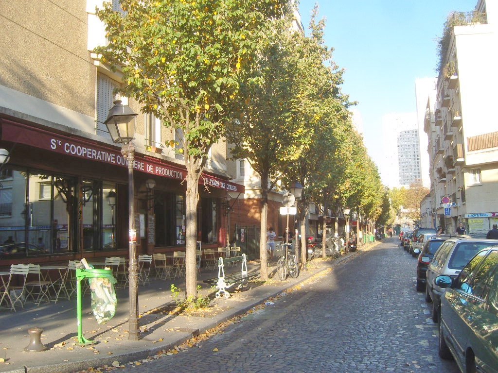
The park is situated between the périphérique and the Boulevard Kellerman, but in the past, this area belonged to the town of Gentilly, as did the nearby cemetery. Paris expanded increasingly over the centuries, which is why parts of Gentilly, once four times larger than today, were annexed to Paris. Exit the park by taking Max Jacob Street and head to Poterne des Peupliers via the street of the same name. Walk up the street, which is now called "Rue des Peupliers", towards Place de l’Abbé Hénocque. You are now in the heart of the area called "Moulin des Prés".
Moulin des Prés
The Moulin des Prés neighborhood is bordered by the streets of Tolbiac, Brillat-Savarin, the Boulevard Kellerman, and Avenue d’Italie. Lovely name, isn’t it?
It recalls the windmill that was located here, powered by the Bièvre.
A bit of history about the river: There were two flows, one called "living" which referred to the flow diverted from the river that brought water to the mills of Paris, and the other called "dead" which was the original watercourse. However, despite these diversions, the river never had a b flow as its incline was very gentle.
Today, you can follow both paths. The neighborhood took its name from a windmill located here since the 16th century. It was destroyed in the 19th century. Today, only a medallion sealed in the alley tells us that it was once there.
Streets Not to Miss
Take the opportunity to explore some of the beautiful streets around Place de l’Abbé Hénocque. The whole neighborhood feels timeless. For example, look at the colorful houses on Dr Leray Street, Damesme Street, and of course Moulin des Prés. Take Henri Pape Street, located to the east of Place de l’Abbé Hénocque, and continue to the intersection of Moulin Street. Here, you’ll see a medallion marking the location of the windmill.
Follow Moulin des Prés Street on the left towards Rue de Tolbiac. Walk down the street on the left. Here, we are not following the exact course of the Bièvre: it flows under the houses! Let’s go straight ahead and search for more medallions, especially across from the Sainte-Anne Church, at the corner of Bobillot Street.
This church, built in a Roman-Byzantine style, was erected between 1894 and 1912. It was partly financed by a couple of chocolatiers who owned a factory in the 13th district. That’s why the façade is called the "chocolate façade" and the two towers are named "Jules and Honorine," after the generous donors!
A new medallion will show you the way: descend Bobillot Street, southwards. You can now choose to follow the street to Place de Rungis and then return northwards via Boussingault and Vergniaud streets, along the lively river course. Alternatively, you can follow the dead river along Brillat-Savarin Street. This street follows the exact course of the river, as you can see on the map.
On my test, I chose to cut through Rue de la Colonie. If you take the same street, you’ll come across lovely graffiti and surprising pieces of architecture.
Take Vergniaud Street northwards.
Parallel to this street, there’s a street called Glacière. In the past, there were marshes and ponds formed by the river. In winter, they froze and provided ice for the summer. The ice was stored in refrigerated pits in the Montsouris area (now the 14th district).
In both cases, you must cross Tolbiac Street. You are now in the Butte aux Cailles neighborhood.
The Butte aux Cailles Neighborhood
Butte aux Cailles means "hill of quails". Isn’t it cute? This neighborhood is appreciated by Parisians because it resembles an old village with its cobbled streets, houses, restaurants, and (sometimes) its budget-friendly bars. Until 1860, it belonged to Gentilly, just like the Moulin des Prés neighborhood you crossed a few minutes ago.
You won’t see the most important streets of the neighborhood by following this route, but of course, you can take a little detour! If you do, look for these streets: Rue de la Butte-aux-Cailles, Rue des Cinq-Diamants.
Continue on Vergniaud Street, northwards
Halfway down the street, don’t miss Rue Daviel, which is perpendicular to Vergniaud Street. This is a street where you’ll see part of what’s called the "Little Alsace", a set of houses with light blue timber framing. Normally, you can’t enter the courtyard, but if you’re lucky, you might meet a resident who will let you in.
At the intersection of Rue Daviel and Rue Vergniaud, there’s an Antonist temple. Look at it carefully, because there are only 32 churches of this new cult in France (it was founded in 1910), and only two others in Paris.
Look for Miss Tic’s graffiti. This artist decorates the streets of Paris, especially in the 13th district, with her paintings and wordplay stenciled in black and red.
Cross Auguste Blanqui Boulevard next to the headquarters of Le Monde newspaper.
Look at the beautiful façade of the building: it features a giant drawing by Plantu, the famous caricaturist of the newspaper.
Take Auguste Blanqui Boulevard eastwards, then turn left onto Croulebarbe Street.
The Gobelins
Croulebarbe Street
You are now in the area called Les Gobelins. Croulebarbe Street follows the exact course of the river with great precision, as you can see on the map. You can take a break for a while in the small Gall Park and pause the walk. At the entrance to the park, you’ll see another medallion, where the Croulebarbe windmill once stood.
Along the park on the left, keep an eye out for more medallions: there are a few! You’ll then come to an austere building called "Mobilier National". It’s time for a "historical" pause.
Mobilier National
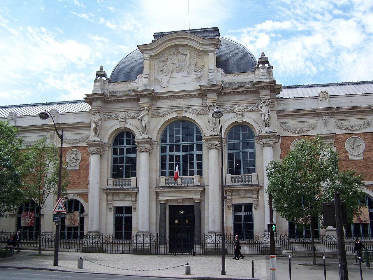
This is where the famous Gobelins Manufacture was built. This neighborhood was home to dyers, tanners, and other trades that needed abundant water for their work. The Gobelins tapestry, founded in 1667, bears the name of dyer Jehan Gobelin who lived on the Bièvre around 1447 and was the patriarch of a long line of dyers.
You can visit the Manufacture to admire the beautiful tapestries in the permanent exhibition. The manufacture is still active today. The Mobilier National is the parent company of the Gobelins and is tasked with furnishing and restoring all official buildings of the French Republic.
Croulebarbe Street is now called Berbier du Mets Street. Continue along this street.
You’ll see more graffiti on the wall in front of Mobilier National. It’s one of the works by the artists known as "Lézarts", a group of artists who offer a chance to discover the Bièvre every year during an "open house" day.
On the street, there’s a curious round building: it’s part of the Gobelins chapel located behind these walls.
Dame Blanche
Take a small detour to the Gustave Geoffroy Street on the right.
In this street, look at the building on your left: it’s called l’îlot de la Dame Blanche. Here you’ll find a small group of houses that are among the oldest in Paris. The block belonged to the Gobelins Manufacture. Legend has it that Blanche, the daughter of King Louis IX (Saint-Louis 1226-1270), had this house built and lived there.
Return to Berbier du Mets Street by taking the Rue des Gobelins on your left. Then cross the Arago Boulevard.
Look at the beautiful façade of the Port-Royal Temple, located on the boulevard.
Descend Arago Boulevard towards the west, take Pascal Street on the right, cross the Port-Royal Boulevard, take Pascal Street again, and then turn right onto Valence Street.
You arrive at the intersection of Gobelins Boulevard with Monge Street, Claude Bernard Street, and Fer à Moulin Street.
Another medallion is sealed in the passage of Gobelins Avenue, where the Saint-Marcel windmill once stood.
Cross the square and take Fer à Moulin Street.
Fer à Moulin means "Windmill in Steel": you're on the right path! At the intersection with Santeuil Street, you’ll find a new medallion marking the passage of the Bièvre.
The Bièvre flows here under modern buildings. You can only follow the streets that are closest, not the exact curve of the river.
Grand Mosque of Paris
Continue until you reach Geoffroy Saint-Hilaire Street and take this street on your left.
If you keep following this street, you will discover the Grand Mosque of Paris. It is the largest mosque in the city, and also the first built in France, as it was inaugurated in 1926.
You can eat something, have a tea, or even relax in the mosque's hammam, or better yet, take a walk in the gardens. They are open to the public.
From now on, you can no longer follow the exact course of the Bièvre, which again flows under modern buildings. The last bend of the river follows Nicolas Houël Street, which is now a dead-end, and ends at Boulevard de l’Hôpital.
You can follow Buffon Street, which leads finally to the Seine. But I suggest ending your walk in the Jardin des Plantes, which is magnificent.
Enter the garden via the gate in front of the mosque, Geoffroy Saint-Hilaire Street.


